 08-16-2011, 03:37 PM
|
#1 |
|
Member

Join Date: Apr 2011
Location: o-side
Posts: 58
|
HELP PLEASE!!!!!!
NEED HELP ON BUYING FISHFINDER WITH GPS OOOOOR FISHFINDER AND A HANDHELD GPS..... SENOR CAYAKERS COMMENT PLEASE THANK YOU RICHARD 
|

|

|
|
08-16-2011, 03:46 PM
|
#2 |
|
Ancient Member

Join Date: Feb 2007
Location: On The Water
Posts: 935
|
Don't buy an HDS until lowrance can fix the crap they have out there!
|
|
|
|
|
08-16-2011, 04:06 PM
|
#3 | |
|
Loves Surface Irons

Join Date: Jun 2008
Location: San Diego
Posts: 455
|
Quote:
|
|
|
|
|
|
08-16-2011, 04:13 PM
|
#4 |
|
Senior Member

Join Date: Sep 2009
Location: newbury park ca
Posts: 2,323
|
H/B 365ci has gps, good meter no trouble in the $3-400 range

|
|
|
|
|
08-16-2011, 04:18 PM
|
#5 |
|
Ancient Member
Join Date: Feb 2007
Location: On The Water
Posts: 935
|
Without going into how bad their last update was...
Lowrance has had an issue with their maps; I.E. leaving the bathemetry and all details including satellite imagery of bottom details cut out of areas of their current maps... From the LaJolla point out 1/2 mile or so and up past solona beach. Even their main map at their head quarters is missing this information. Their engineers and customer service reps have both confirmed the issue is affecting all units, but failed to return several of our calls to, at the very least, explain this. Units as expensive as the HDS5, 7 and Elite 5 should have complete maps as they are advertised to with the Nautic insight. None of us should not have to go purchase the navionics after spending money for faulty software from Lowrance's Nautic insight. My Raymarine 545s, and the Garmin GPS units I own both have very detailed maps of the area. Notice the loss of the pink bathemetry lines and spot depth markings in the area I mentioned above in the photo below. Ignore the track log... nothin to see here. 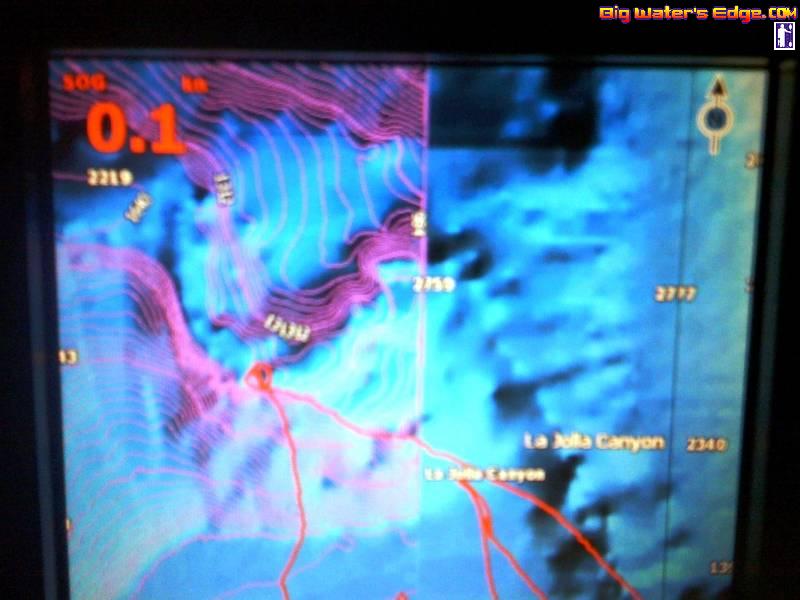
Last edited by Handymansd; 08-16-2011 at 05:02 PM. |
|
|
|
|
08-16-2011, 04:42 PM
|
#6 |
|
Senior Member

Join Date: Apr 2010
Posts: 6,856
|
Eagle Cuda 350.....
__________________
 www.facebook.com/Teamsewer |
|
|
|
|
08-16-2011, 04:42 PM
|
#7 |
|
Loves Surface Irons
Join Date: Jun 2008
Location: San Diego
Posts: 455
|
Yep thought that might be the case. I hear about this problem happening a lot. C'mon Lowrance show us HDS owners some love.
|
|
|
|
|
08-17-2011, 10:42 AM
|
#8 |
|
Junior
Join Date: Apr 2011
Location: Port Washington, New York (No. Shore of Long Island, Nassau Co.)
Posts: 3
|
Handyman -
Okay, now you've got me worried.  I just purchased an Elite 5 from OEX Mission Bay that is due to be shipped out to me with my new Stealth 14 in the coming days ahead. I hope there are no issues with this unit when I get it and start using it here in NY. I went with CJ's advice & opted for the Lowrance over the Humminbird and others as he said they tend to hold up much better than the others in saltwater environments... had not heard about these mapping issues until just now. Bummer... |
|
|
|
|
08-17-2011, 12:04 PM
|
#9 | |
|
Ancient Member
Join Date: Feb 2007
Location: On The Water
Posts: 935
|
Quote:
I have no idea about the maps in NY, but when some of the primary fishing grounds for yak fisherman here in Southern California are absent from their maps, and their carelessness about customer service and support; it makes you wonder about their commitment to being a quality product. I am sorry to make you wonder but I am pissed at spending that kind of money and having them tell me.... nothing. As for the unit itself I think Lowrance has the best unit out there for the money, great imaging, easy to use, and excellent unit for a kayak, however with bad customer service it does bring down the overall value of having a good unit. just my 0.02. Good Luck in NY and be sure to post your success for all of us to share with you! |
|
|
|
|
|
08-17-2011, 09:33 PM
|
#10 |
|
Member
Join Date: Apr 2011
Location: o-side
Posts: 58
|
thankyou all
I GUESS THAT IT'S GOOD TO HAVE A HANDHELD GPS AND F-F WITH GPS..
STILL WORKING 6 DAY WEEK TILL MIDDLE OF SEP. I CAN KAYING THEN.  
|
|
|
|
 |
| Thread Tools | |
| Display Modes | |
|
|


 Linear Mode

