|
|||||||
| Home | Forum | Online Store | Information | LJ Webcam | Gallery | Register | FAQ | Community | Calendar | Today's Posts | Search |
 |
|
|
Thread Tools | Display Modes |
 02-20-2007, 12:48 PM
|
#1 |
|
Senior Member
Join Date: May 2006
Posts: 698
|
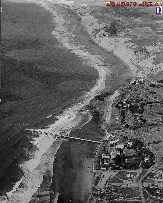
Photo showing Scripps Canyon at Blacks
|

|

|
|
02-20-2007, 01:07 PM
|
#2 |
|
Spam Sanitation Dept

Join Date: Jan 2007
Posts: 1,374
|
very cool picture Dave...
I didn't even know the pier was there that long ago. I knew about some of those buildings on the campus, but not the pier. |
|
|
|
|
02-20-2007, 01:19 PM
|
#3 |
|
Administrator

Join Date: Mar 2005
Location: 1-2 miles off the point
Posts: 6,943
|
the pier must have been shorter or the underwater topography has sure changed for it to be breaking even with the pier to the north. Although it looks like we have lost alot of sand in 60 years. Cool pic Dave, probably took it from a dirigible

__________________
 
|
|
|
|
|
02-20-2007, 02:21 PM
|
#4 |
|
Senior Member

Join Date: Mar 2005
Location: "The Table"
Posts: 976
|
Andy- It looks like the tide goes all the way up to the cliff. I no that happens north of the pier, but what about where the houses are?
Matt |
|
|
|
|
02-21-2007, 09:23 AM
|
#5 |
|
Senior Member
Join Date: Mar 2005
Location: San Diego CA
Posts: 947
|
Scripps Pier was originally built in 1916 and remained until 1988 when it was rebuilt. I have a piece of wood from the original pier at my house.
 Here is a little more information The land that SIO is on was originally purchased from the city for $1000. http://www.explorations.ucsd.edu/back/exp_pdfs/Volume_7_n1/The_Biological_Colony_V7n1.pdf
__________________
Jim Sammons La Jolla Kayak Fishing The Kayak Fishing Show JimSammons.com 
|
|
|
|
|
02-21-2007, 09:49 AM
|
#6 |
|
Junior Member
Join Date: Oct 2005
Posts: 19
|
awesome pic's, lots of history here.
__________________
----------- ---Ken--- ----------- rolling in the surf is a speciality enjoyed more by the onlookers |
|
|
|
|
02-21-2007, 10:35 AM
|
#7 |
|
Senior Member
Join Date: Mar 2005
Location: San Diego CA
Posts: 947
|
Even more information than you probably want. Thanks to the kind lady at SIO for sending this to me.
Ellen Browning Scripps Memorial Pier (1) Background The Pier at UCSD's Scripps Institution of Oceanography is an important support facility for research and educational activities. It also serves as a collection site for clean seawater, marine animals, atmospheric and oceanic data and as a launching site for small boats. Since construction of the original pier in 1916, the Scripps Pier has been a prominent landmark on the La Jolla coastline. Since August 1916 the pier has been the site of daily seawater temperature and salinity measurements, the longest continuous readings of such ocean parameters. The Scripps Pier .houses the oldest tide gauge station in the open ocean on the west coast, installed in 1924. (2) NEW PIER Name: Ellen Browning Scripps Memorial Pier, named in honor of Ellen Browning Scripps, benefactress of Scripps Institution and donor of $36,000 for the construction of the original Scripps Pier. Construction; Began February 1987, just south of old pier. Length: 1,084 feet Width: 22-1/2 feet Height: 34 feet above mean lower low water at end of pier Submarine Canyon: 2,600 feet west from pier - 600 feet deep Seawater System: Two new, 1,200-gallon-per-minute (GPM) pumps and one 850 GPM pump, salvaged from the old pier, supply fresh seawater to a gravity flume system extending the length of the pier to three large sand filter tanks on the shore. Secondary pumping systems pump water to two sets of holding tanks from which it is distributed by gravity to buildings and laboratories throughout Scripps and the Southwest Fisheries Center at the rate of 1.8 million gallons per day. Boat Launching: A 3-ton boat launching hoist lowers boats in support of diving operations and nearshore biological and underwater research. Laboratory Space: Approximately 1,000 square feet house hard-wire links to offshore computerized instruments, tide gauges, water sampling, and weather instruments. It also serves as a testing site for various types of instruments prior to use aboard ships or in other locations and numerous temporary lab uses for student experiments. Pier Material: All Concrete Piling Material:Pre-stressed concrete Piling Length: 76 feet maximum Depth: 42 feet below mean lower low water Design Firm:Ferver Engineering, San Diego, California Construction:Kiewit Pacific Company, Vallejo, California Cost: $3,950,000 Funded by: State of California Research Uses: __500 boat launchings per year _Many oceanographic instruments deployed from pier. By using pier scientists an bypass 95 percent of surf _NOAA wave sensors are mounted on bottom at the end of the pier. _Plankton samples can be taken from end of the pier in nets or in flume. _Water temperatures (top and bottom) are taken from end of pier every day. _Pier gives continuous means of conducting research beyond the surf line without launching a boat. (3) Old Pier: Built: 1915-16 at a cost of $36,000 Funding: Ellen Browning Scripps Length: 1,018 feet Width: 20 feet Construction: Wood with concrete pilings. Pilings had been reinforced several times over the years to strengthen. Demolished: Spring 1988
__________________
Jim Sammons La Jolla Kayak Fishing The Kayak Fishing Show JimSammons.com
|
|
|
|
|
02-21-2007, 09:03 PM
|
#8 |
|
Member
Join Date: Mar 2005
Location: Santee
Posts: 44
|
I love the old pictures of the San Diego Beaches and bays. They always make me wonder what it would be like if we had the fish populations from those days with todays fishing gear. Oh and it would be nice if teh human population was the same as it was back then too.
Where exactly is the old LJ farm? Is that it in the top right hand corner of the first picture? Brett D. |
|
|
|
|
02-22-2007, 06:35 AM
|
#9 |
|
Waterman At Large
Join Date: Oct 2006
Location: On the Water
Posts: 199
|
The recent posts regarding water etiquette and the "rights" of the "locals" make me think how unfortunate it is that people today have lost the sense of history that surrounds the beaches and waters of La Jolla.
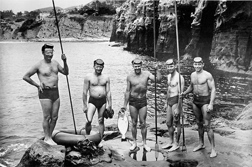 San Diego Bottom Scratchers  Bob Simmons - Why Windansea will always be a waterman's shrine As we walk across the same beaches as these legends, what will our generation contribute to this legacy?
__________________
Kayak Fishing Photos and Video |
|
|
|
|
02-22-2007, 10:21 AM
|
#10 |
|
Senior Member
Join Date: Mar 2005
Location: Persian Gulf
Posts: 263
|
Wow Ronbo! that San Diego Bottom Scratchers link is awsome. Check out those WSB. Love to go back in time
__________________
 When I grow up I want to be, One of the harvesters of the sea, <O  I think before my days are done, I want to be a fisherman. |
|
|
|
|
02-22-2007, 10:58 AM
|
#11 |
|
Senior Member
Join Date: Mar 2005
Location: Point Loma
Posts: 384
|
What a cool photo of the pier and the canyons.
Has anybody seen anything like that but more recent-I don't see why that photo can't be duplicated on a clear water day with the right sun conditions. I would like to see if they changed and how far out the edges go-as opposed to looking at my fishfinder. Dave
__________________

|
|
|
|
|
02-22-2007, 12:15 PM
|
#12 | |
|
Junior
Join Date: Mar 2005
Location: San Diego
Posts: 24
|
Quote:
Mark |
|
|
|
|
|
02-22-2007, 03:10 PM
|
#13 |
|
Member
Join Date: Mar 2005
Location: Santee
Posts: 44
|
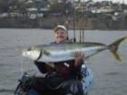
Nice links Ronbo. We have a picture of my dad on a longboard at La Jolla in the 60's with 3 huge WSB laid across the front. If I am not mistaken he won a spear fishing contest that day.
|
|
|
|
|
02-22-2007, 06:47 PM
|
#14 |
|
Paddle for Mahi
Join Date: Mar 2005
Location: Doing the happy paddle!
Posts: 846
|
Great resources guys!
The breakers were breaking before the new pier on Tuesday.  Ken |
|
|
|
|
|
|


 Linear Mode

