|
|||||||
| Home | Forum | Online Store | Information | LJ Webcam | Gallery | Register | FAQ | Community | Calendar | Today's Posts | Search |
 |
|
|
Thread Tools | Display Modes |
 06-25-2007, 09:19 PM
|
#1 |
|
Senior Member
Join Date: Mar 2005
Posts: 719
|
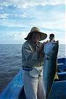
The most important Cisquito pic
I feel I should show you this because you should not do this alone and plan carefully. If you go, have Ernie panga assist you. This current was so bad that we would have schools of YT come up along side the yaks and boil on bait. We woudl continue to paddle against the current and not cast because the ground lost would be too great.  If anyone decides to go and needs info on the gfishery, tides, Beto's and Ernie's panga - I'll be sure to help. For you long range planners. July-October is hot and hurricane season. November is the best month. Decmber starts the El Norte's. |

|

|
|
06-26-2007, 09:28 AM
|
#2 |
|
Senior Member

Join Date: May 2007
Location: Chula Vista
Posts: 1,589
|
Thanks for the photo. You're right that it doesn't quite do justice to the situation. I have seen similar conditions on the south end Of Isla Tibaron off Muleje. Even in a skiff it was scarey. From the high, or up hill, side you can't see it coming from a low boat. We were drifting along and then we speeded up and fell over the edge of a standing wave. It was like finding a hole in the ocean. F'n scarey and it must be even worse in a kayak. Mike
|
|
|
|
|
|
|


 Linear Mode

