Kayak Fishing Adventures on Big Water’s Edge  

Go Back   Kayak Fishing Adventures on Big Water’s Edge > Kayak Fishing Forum - Message Board > General Kayak Fishing Discussion
Home Forum Online Store Information LJ Webcam Gallery Register FAQ Community Calendar Today's Posts Search

Reply
 
Thread Tools Display Modes
Old 12-06-2010, 09:42 AM   #1
old_rookie
Senior Member
 
old_rookie's Avatar
 
Join Date: Mar 2010
Location: Santee
Posts: 904
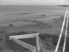
Yeah, I fished LJ - but where??

Not a report...

This is where I went for my outing... the link is only good for 30 days or something...

Name:
LJ skunk dec 4 2010
Date:
Dec 4, 2010 8:29 am
Map:
(valid until Jun 4, 2011)
View on Map
Distance:
4.06 miles
Elapsed Time:
4:54:20
Avg Speed:
0.8 mph
Max Speed:
4.7 mph
Avg Pace:
72' 34" per mile
Min Altitude:
0 ft
Max Altitude:
4 ft
Start Time:
2010-12-04T16:29:05Z
Start Location:


Latitude:
32.855960º N

Longitude:
117.257939º W
End Location:


Latitude:
32.856445º N

Longitude:
117.257566º W
old_rookie is offline   Reply With Quote
Old 12-06-2010, 03:23 PM   #2
Iceman
Administrator
 
Iceman's Avatar
 
Join Date: Mar 2005
Location: 1-2 miles off the point
Posts: 6,943
technology is cool!
__________________
Iceman is offline   Reply With Quote
Old 12-06-2010, 03:26 PM   #3
Caballito
Member
 
Caballito's Avatar
 
Join Date: Apr 2007
Location: San Diego
Posts: 42
you missed 2 left turns
__________________
Caballito
Caballito is offline   Reply With Quote
Old 12-06-2010, 06:03 PM   #4
StinkyMatt
Senior Member
 
StinkyMatt's Avatar
 
Join Date: Jun 2010
Location: Under a bridge
Posts: 2,168
Ha! Now I know everything I needed to know! That is pretty cool, now what will you do with your data?
StinkyMatt is offline   Reply With Quote
Old 12-06-2010, 06:08 PM   #5
Fiskadoro
.......
 
Fiskadoro's Avatar
 
Join Date: Jan 2009
Posts: 1,509
Amazing resolution..

Anyone else notice the yellow (papaya) Hobie peddling outside?

Jim
Fiskadoro is offline   Reply With Quote
Old 12-06-2010, 06:08 PM   #6
roadx
.
 
roadx's Avatar
 
Join Date: May 2010
Posts: 1,155
heres one back in august, towing greenbacks in deeper water


__________________
roadx is offline   Reply With Quote
Old 12-06-2010, 10:04 PM   #7
old_rookie
Senior Member
 
old_rookie's Avatar
 
Join Date: Mar 2010
Location: Santee
Posts: 904
Quote:
Originally Posted by StinkyMatt View Post
Ha! Now I know everything I needed to know! That is pretty cool, now what will you do with your data?
I titled the track as skunk - so next time I'll make sure not to go there again!!

Save it and show my grandkids???
Use it as an alibi??
old_rookie is offline   Reply With Quote
Old 12-06-2010, 10:05 PM   #8
old_rookie
Senior Member
 
old_rookie's Avatar
 
Join Date: Mar 2010
Location: Santee
Posts: 904
Quote:
Originally Posted by roadx View Post
heres one back in august, towing greenbacks in deeper water


That's cool. Are you able to view that while you are peddling?
old_rookie is offline   Reply With Quote
Old 12-07-2010, 04:57 AM   #9
Regor
Greg
 
Regor's Avatar
 
Join Date: May 2010
Location: Chula Vista, ca
Posts: 509
Quote:
Originally Posted by old_rookie View Post
Not a report...


Min Altitude:
0 ft
Max Altitude:
4 ft
I assume this mean 4' swells that day
Regor is offline   Reply With Quote
Old 12-07-2010, 05:09 AM   #10
roadx
.
 
roadx's Avatar
 
Join Date: May 2010
Posts: 1,155
Quote:
That's cool. Are you able to view that while you are peddling?
yes, its a program/map set called blue charts by garmin, it has more detail when zoomed in. shows ship wrecks, reefs, obstructions, buoys and also has good detail of the bays too
__________________
roadx is offline   Reply With Quote
Old 12-07-2010, 05:56 AM   #11
Jzo
Senior Member
 
Jzo's Avatar
 
Join Date: Aug 2010
Posts: 344
Quote:
Originally Posted by old_rookie View Post
Not a report... This is where I went for my outing... the link is only good for 30 days or something...
Quote:
Originally Posted by roadx View Post
yes, its a program/map set called blue charts by garmin, it has more detail when zoomed in. shows ship wrecks, reefs, obstructions, buoys and also has good detail of the bays too
Very cool indeed, thx for sharing.
Jzo is offline   Reply With Quote
Old 12-07-2010, 07:04 AM   #12
old_rookie
Senior Member
 
old_rookie's Avatar
 
Join Date: Mar 2010
Location: Santee
Posts: 904
Quote:
Originally Posted by Regor View Post
I assume this mean 4' swells that day
Since I carry the GPS on me, it was when I stood up to get out of the kayak at the beach.
old_rookie is offline   Reply With Quote
Reply


Posting Rules
You may not post new threads
You may not post replies
You may not post attachments
You may not edit your posts

BB code is On
Smilies are On
[IMG] code is On
HTML code is On

Forum Jump


All times are GMT -8. The time now is 12:57 AM.


Powered by vBulletin® Version 3.8.11
Copyright ©2000 - 2024, vBulletin Solutions Inc.
© 2002 Big Water's Edge. All rights reserved.