|
|||||||
| Home | Forum | Online Store | Information | LJ Webcam | Gallery | Register | FAQ | Community | Calendar | Today's Posts | Search |
 |
|
|
Thread Tools | Display Modes |
 12-17-2010, 10:22 PM
|
#1 |
|
Senior Member
Join Date: Mar 2005
Location: Spring Valley
Posts: 1,400
|
What are the Dec 16th MLPA results?
__________________
"Never say die" |

|

|
|
12-18-2010, 07:56 AM
|
#2 |
|
Kayaker

Join Date: Mar 2005
Location: Big Rock, WindanSea, La Jolla
Posts: 413
|
We know that the north and south boundaries of the South La Jolla were
moved at the last minute, to include greater area, apparently the northern boundary at "pink wall" was moved to a street north of WindanSea. Ouch. I live right here on Palomar Ave above Big Rock, and the *proposed* increased SLJ closure now encompasses 100% of my fishing beach, and, 90% of my kayak fishing spots. I say *proposed* because there is the funding/enforcement issue, and, court battles to come. The process: I went to some of the meetings, however I am one who believes that more fishermen participation at the MLPA meetings would not have changed much. They didn't really care. If anyone has a link that discusses the new northern *proposed* boundary of SLJ closure, please post.
__________________
Larry. Hobie Revolution 13. 25 years of kayak fishing La Jolla. https://larryl.com/photos |
|
|
|
|
12-18-2010, 08:35 AM
|
#3 | |
|
Administrator

Join Date: Mar 2005
Location: 1-2 miles off the point
Posts: 6,943
|
Quote:
__________________
 
|
|
|
|
|
|
12-18-2010, 05:29 PM
|
#4 |
|
Senior Member
Join Date: Mar 2005
Location: Spring Valley
Posts: 1,400
|
Thanks you two.
So it sounds like shenanigans were pulled. Now, it sounds like, we wait to see as to what is, or isn't approved for closure.
__________________
"Never say die" |
|
|
|
|
12-19-2010, 10:31 AM
|
#5 |
|
Kayaker
Join Date: Mar 2005
Location: Big Rock, WindanSea, La Jolla
Posts: 413
|
Thanks Andy, my buddy put the boundary lat long coordinates into his
GPS wrong, and almost gave me a heart attack!! Personally I think they have an uphill battle for this to actually be implemented .... But if it passes, I'm on the boundary. Probably the best spot for lobstering in a couple of years! |
|
|
|
|
12-19-2010, 11:39 AM
|
#6 |
|
Senior Member
Join Date: Apr 2010
Posts: 175
|
As it stands...
 or you can go to this link so that you can zoom in... http://www.dfg.ca.gov/mlpa/pdfs/scmpas121510.pdf ...and not to be a dick but, comments stating that you'll be lobstering the edge of the reserve because that's where the action will be in a few years translates directly to, "MLPA's work" to the enviro's and can be used as fuel to feed this ridiculous fire. We've met a few times in the past (it's Larry right?) and really nothing personal, just my 2 cents...so take it for what its worth! |
|
|
|
|
12-19-2010, 11:56 AM
|
#7 |
|
Senior Member
Join Date: Sep 2010
Location: Encinitas
Posts: 395
|
Still trying to understand what the difference between the reserve and conservation (blue and red).
|
|
|
|
|
12-19-2010, 12:12 PM
|
#8 | |
|
Senior Member

Join Date: Oct 2009
Location: Coto de Caza, CA
Posts: 155
|
Quote:
What is really tricky is the SMCA's. They can allow recreational fishing, but you need to read the regulations. I put in a separate post how the Newport Back Bay used to say fishing is allowed with hook and line, but apparently the language may change to where this allowed only from shore. Why this distinction is being added is confusing because they are not restricting boats from going into the back bay. Kevin |
|
|
|
|
|
12-19-2010, 02:28 PM
|
#9 |
|
Senior Member
Join Date: May 2005
Posts: 754
|
^No, that's not quite right.
Unfortunately, each one of those blue areas can have different rules. Some are virtually the same as reserves, allowing only things such as sewage outlet maintenance and sampling. Others, like the one over Scripps Pier, allow some fishing. Crucially for us, we can fish bait there. That didn't happen by accident. We battled for it. |
|
|
|
|
12-19-2010, 05:44 PM
|
#10 |
|
Kayaker
Join Date: Mar 2005
Location: Big Rock, WindanSea, La Jolla
Posts: 413
|
@Aaron The buoys are piled on top of each other at the La Jolla Cove
boundary, San Diego Bay commercial boundary, and the Santa Monica Bay commercial boundary. Are they there by accident? It took me 5 minutes to google this up. http://cmbc.ucsd.edu/Students/Curren...llEtAl2007.pdf From page 36, "The last important pattern is that fishing is concentrated near the western edge of the Reserve. This area has good lobster habitat (as defined in Parnell et al. 2006), but it is still fished disproportionately higher than similar habitat further south. This suggests that the fishermen are targeting spillover from the reserve. This argument is further supported by the fact that fishermen are concentrating their traps near the Reserve proportionately more during the middle and latter stages of the season suggesting that most of the legal-sized lobster left by the end of the season are those moving out of the Reserve. Traps were also observed immediately north of the northern boundary of the Reserve during the latter half of the season. This entire area is a sandy shelf and devoid of lobster habitat and therefore was not surveyed for traps. However, the presence of traps in such poor habitat during the latter part of the season, and not near the beginning, further suggests that the fishermen are fishing spillover from the Reserve." The most important question is: Do you really think that any statement made by me would change the vote of the 5 people that really matter? |
|
|
|
|
12-19-2010, 07:49 PM
|
#11 | |
|
Senior Member
Join Date: Oct 2009
Location: Coto de Caza, CA
Posts: 155
|
Quote:
I spent some time this afternoon going over the DFG descriptions for some of the SMR's/SMCA's actions and it is confusing what they do and do not restrict. I focused primarily on the areas I fish in Orange County and it seemed the rules were written using the same thought process as in Joseph Heller's novel Catch-22. Kevin |
|
|
|
|
|
12-19-2010, 08:11 PM
|
#12 |
|
Senior Member
Join Date: Mar 2009
Posts: 2,384
|
For the most part, the blue areas are closed to fishing for us. Unless you plan on harpooning billfish which is allowed in several of them.
I don't think that even the most avid anti-MLPA people would argue that the perimeters of the reserves would likely provide a better opportunity to catch fish than the barren sand they are leaving us in between. Their arguement is that overall fishing will be better with MPAs. And they incorrectly use the best possible example (the perimeter) of current reserves as indication of how our entire coastline will respond. Just like all their other arguments, 2 half truths do not make the truth that they want to imply. |
|
|
|
|
12-19-2010, 08:35 PM
|
#13 |
|
Senior Member
Join Date: Oct 2009
Location: Coto de Caza, CA
Posts: 155
|
I do not know how much this will change, but here is a link to the DFG's list of options they had with will be allowed in the various MLPA's and the "scorecard" which shows what options they selected:
http://www.dfg.ca.gov/mlpa/pdfs/section632title14.pdf http://www.dfg.ca.gov/mlpa/pdfs/scmp...0scorecard.pdf |
|
|
|
|
12-19-2010, 09:10 PM
|
#14 |
|
Kayaker
Join Date: Mar 2005
Location: Big Rock, WindanSea, La Jolla
Posts: 413
|
Thanks GregAndrew. Thats what I meant to say
 So Aaron, if someone uses that "Edges of The Reserve" argument on you, you have a softball pitch to hit out of the park. (On the other hand, I also understand the sensitive nature of some of the 'activists' - even a picture of a great kayak catch is enough to bring them to tears. ") Like my brother, who can't wait to get his Like my brother, who can't wait to get his Nissan Leaf next year.  ) )
|
|
|
|
|
12-19-2010, 10:00 PM
|
#15 | |
|
Senior Member
Join Date: Apr 2010
Posts: 175
|
Quote:
I guess my point wasn't clear and its really no big deal. Not at all trying to say that you are in any way hurting the process. Just trying to point out that the things we say/type/blog "can and will be used in a court of law". I've interacted, and continue to interact with these people on a fairly consistent basis as it is the nature of the "scientific community" beast. The point they bring up again and again is that places like La Jolla are so productive for fishermen b/c of the reserve (it has nothing to do with the insane amount of upwelling that comes out of the canyon, right?) and that "the fishermen know it". Its all complete shenanigans and we all hate it. My apologies for calling you out on the forum. That was a dick move. The comment just rang my memory a bit of some conversations I've had with this group in the past. Mostly, I'm pissed b/c it is my first weekend of holiday, I finally got my gear all back in order, and in comes "storm watch 2010"!! Now I'm stuck once again reading BWE and griping about MLPA's when I finally have an opportunity to be out on the water!!! I'll be happy to sit on the edge of the reserve with you someday pulling hoops, but hopefully those plans will be all for not after this all gets crushed in court! |
|
|
|
|
|
12-20-2010, 11:08 AM
|
#16 | |
|
Senior Member

Join Date: Jun 2009
Posts: 186
|
Quote:
problem is that even if that were true, and in reality it's total bullshit as where's the habitat and structure for the new larvae to grow, there's no way possible to measure the actual reserve effect. it'll take years for new populations to appear (think the slow growing calico) and even then, shouldn't it be the case that the larvae would have already dispersed and there'd be fish populations elsewhere. fishing "the edge of the reserve" isn't going to affect the so called larval dispersions at all. the problem that they never bothered to address (well, why would they, it was NEVER about fish) was where are all the new fish going to live. hell, no structure, no fish. |
|
|
|
|
|
12-20-2010, 12:08 PM
|
#17 | |
|
Senior Member
Join Date: Mar 2005
Location: Spring Valley
Posts: 1,400
|
Quote:
__________________
"Never say die" |
|
|
|
|
|
12-20-2010, 01:02 PM
|
#18 |
|
Kayaker
Join Date: Mar 2005
Location: Big Rock, WindanSea, La Jolla
Posts: 413
|
This works
http://www.dfg.ca.gov/mlpa/pdfs/scmpas121510.pdf only if you cut and paste into your browser. |
|
|
|
|
12-20-2010, 01:25 PM
|
#19 |
|
Member
Join Date: Oct 2009
Location: San Gabriel Valley
Posts: 89
|
Reef balls and synthetic kelp
Can we look into a combined effort with local organizations and do a BWE Reef ball and synthetic kelp construction project? If reserves are left reserves they become unbalanced. Only so many fishies and crustaceans can live in one area. Lets give the ocean more creature housing and increase our catches!
|
|
|
|
|
12-21-2010, 03:39 PM
|
#20 |
|
Senior Member
Join Date: May 2009
Location: wherever the college girlz r
Posts: 127
|
http://www.dfg.ca.gov/mlpa/finalimpact_sc.asp
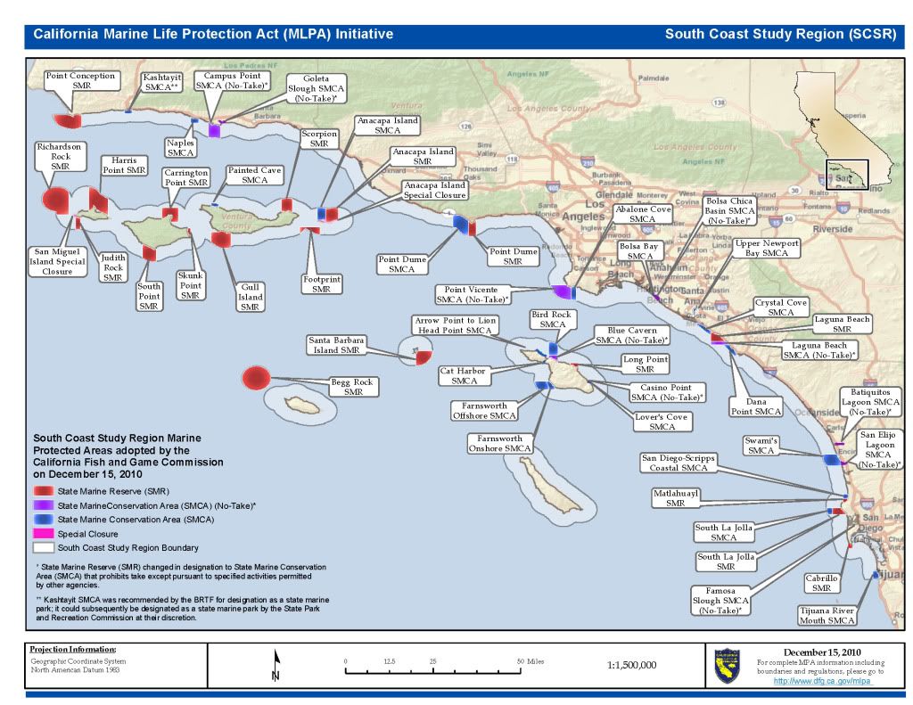
Ok I just found this on the website when I went to check Melissa's latest e-mail on the EIR for SoCal. I never saw this map before. Is this what DFG approved as the final? The map that Blackcloud posted below looks like an old version, but they are roughly the same. I can live with this - it seems like the main buoy gets pushed west a little further and "the spot" is now protected. I guess it could have been worse - but what a waste of money. |
|
|
|
|
|
|


 Linear Mode

