|
|||||||
| Home | Forum | Online Store | Information | LJ Webcam | Gallery | Register | FAQ | Members List | Social Groups | Calendar | Search | Today's Posts | Mark Forums Read |
 |
|
|
Thread Tools | Display Modes |
 08-01-2016, 01:21 PM
|
#1 |
|
Senior Member
Join Date: Jun 2016
Location: Escondido, CA
Posts: 130
|
Oceanside Artificial Reef
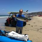
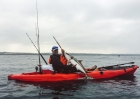
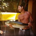
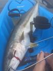
I set out Sunday to go fish the artificial reefs outside Oceanside. Friday night, I entered all the coordinates into my GPS and found that it was necessary to convert the coordinates from one format to another. Having worked through all the 20 waypoints, I set to packing and prepping my equipment. The initial plan was to head out Saturday morning, but the work week left me far too exhausted to wake early enough. Sunday was the ticket. Sunday morning, 6:45am I head out two hours later than planned. Damn how nice it would be to not have to work all damn week. Just head out fishing whenever you want... I hope I can do that in retirement. Arrival in the harbor came not much later and soon I was in my kayak heading to the nearest waypoint. Not wanting to waste money on buying live bait, I started catching some on the way. This went fairly well as I soon had a dozen small macs in my tank. I was a little disappointed by the size, but I pinned one on just in the off chance of a wandering YT. By 8ish I arrived where I my GPS said the artificial reefs start but sonar completely disagreed. Examining my GPS, I see that this waypoint was far too isolated, an apparent artifact of me entering the coordinates wrong, so I head to the next point. Same result, but the GPS says there is a cluster of rock piles in this area though Sonar still disagrees. Going from point to point, I find that the water is getting far deeper than the reef should be in. I am now convinced that I totally screwed up the coordinate conversion. (from Deg, Min, Sec to Deg, Min.xxx) Not wanting to waste the time, effort, or energy required to get out here, I decide to drop a line and drift around. Perhaps some enterprising Halibut is wandering around looking for some squid (Brought along). After about 30 minutes of drifting, I get a hit. A big hit. The fight was initially quite strong, but suddenly became less enthusiastic. I pull up this rather large Kelp Bass and see what went wrong. He was hooked properly, but in his fighting managed to get tangled in the leader. He was a good 18" and weighed a good 5lbs at least. During the process of untangling him and removing the hook, a rather large shrimp dangles out of his mouth. I remove this to find that this guy also found a small octopus. Fascinating to see what these guys eat. Apparently bringing him up from 100 feet of water caused him to dump his contents. Leaving his catch in his mouth, I returned him to the sea and wished him a prosperous journey. Reset my line with a fresh squid and started drifting again. Soon a small halibut is on the line. He is quickly released without even bringing him in the kayak. Free to grow some more and become dinner at some future date. I tool around for another hour then head to the pier since nothing is going on. After exploring the pier for a while and dodging one dudes cast AT me (Those dudes can be real asses at times), I head to the outer breaks thinking perhaps some hungry halibut could be wandering around there. Nothing. Another hour passes. I then decide to head into the harbor where I have had some luck in the past. Instead of heading directly in, I decide to have some fun and ride just outside the outer breakers. This was quite a bit of fun, riding up the waves just before they crest over. A little dangerous perhaps, but it was rather entertaining and made for some good exercise. Soon I am in the harbor drifting around. No bites again. Nothing for hours. Seeing as it is now after 2PM and the wind is picking up, I call it a day. On the way in, I run across another kayaker who is experimenting around with his first kayak fishing run. We talked for a while and after recommending he come to this forum, we part ways. Packed up, headed home. Now that I have properly converted coordinates, I hope next weekend is more productive. It would be nice to have some good action. |

|

|
|
08-01-2016, 01:47 PM
|
#2 |
|
Senior Member
Join Date: Dec 2010
Posts: 228
|
Thx for the report and taking the time to story line it. Always a better read and enjoyable this way.
|
|
|
|
|
08-01-2016, 01:54 PM
|
#3 |
|
Senior Member
Join Date: Jul 2012
Location: Oceanside, CA
Posts: 419
|
Great report...
You had just about the same experience I have had with my GPS coordinates. I haven't landed on anything based on numbers. I randomly find a mound here and there and then save that spot for another time. I have never pulled anything worth while from a spot out there yet. But you never know when the next bite will come. Just got to keep plugging away. Good job, Maybe I will see you out there sometime.
__________________
   
|
|
|
|
|
08-01-2016, 02:04 PM
|
#4 | |
|
Member
Join Date: Jan 2013
Location: San Marcos, CA
Posts: 61
|
Quote:
|
|
|
|
|
|
08-01-2016, 02:40 PM
|
#5 |
|
Senior Member

Join Date: May 2016
Location: Encinitas
Posts: 200
|
That's a crazy looking bass
|
|
|
|
|
08-01-2016, 02:40 PM
|
#6 | |
|
.....
Join Date: Jun 2015
Location: Carlsbad
Posts: 135
|
Quote:
|
|
|
|
|
|
08-01-2016, 03:30 PM
|
#7 |
|
Senior Member

Join Date: Feb 2011
Location: Carlsbad
Posts: 143
|
Thats a barred sandbass, kelp bass are calicos.
If that thing was 18 inches and 5lbs it must have been stuffed solid. Those OAR coordinates are bullsheet. I've been out there and went through the same junk. Likewise, I have found other areas on our coast to have either missing rock piles or incorrect numbers as stated on fishing charts. Sometimes though, you get lucky and everything is where it should be and the sonar is beautiful. Best to hunt around for your own numbers or get a hot tip on someone who actually found something.
__________________
2012 Dune Pro Angler 14, 1994 Yellow Scupper Pro  
|
|
|
|
|
08-01-2016, 05:21 PM
|
#8 |
|
Senior Member

Join Date: May 2013
Location: Inland Empire
Posts: 370
|
Good Time
Don't discount those learning curves. Tuition can be expensive but the lessons are well ingrained.
|
|
|
|
|
08-02-2016, 07:03 AM
|
#9 |
|
Senior Member

Join Date: Mar 2014
Location: The city of Orange
Posts: 1,278
|
Thanks for taking the time to write up a nice report.
|
|
|
|
|
08-02-2016, 09:32 AM
|
#10 |
|
Made in U.S.A.

Join Date: Oct 2012
Location: Dana Point
Posts: 1,625
|
Charts should get you close. I know I have the Pipe at DP marked on my Navionics card but it's a couple hundred yards off which had me scratching my head for a few trips.
__________________
Hobie PA 14 ¸.·´¯`·.´¯`·.¸¸.·´¯`·.¸><(((º> Jackson Kraken ¸.·´¯`·.¸.·´¯`·.´¯`·.¸¸.·´¯`·.¸><(((º> Malibu X-Factor ¸.·´¯`·.´¯`·.¸¸.·´¯`·.¸><(((º> Malibu Stealth-12 ¸.·´¯`·.´¯`·.¸¸.·´¯`·.¸><(((º> Its not a spelling B its a fishing B ~yakjoe
|
|
|
|
|
08-02-2016, 10:40 AM
|
#11 |
|
Member

Join Date: Mar 2011
Location: San Diego, CA
Posts: 89
|
Thanks for the great report.
Same thing happen to me. I got the coordinates for AR's but could never found them on my sonar... Cheers. |
|
|
|
|
08-02-2016, 01:19 PM
|
#12 |
|
Junior
Join Date: Nov 2015
Location: San Marcos, CA
Posts: 28
|
Nothing like standardized units, eh.
Isn't it crazy how many different units are used for GPS by different people. The coordinates I found for all the SoCal reefs are all in Degrees/Minutes/Seconds. Then there is Decimal Degrees to six decimal places, then there is Degrees/Minutes/Decimal Minutes. Most people use the latter, I believe, because that is preferred by the USCG. I would think decimal degrees would be easiest, but it is definitely important to do the conversions right, or you will
be way off. 
|
|
|
|
|
08-02-2016, 03:47 PM
|
#13 |
|
Senior Member
Join Date: Feb 2016
Location: San Diego, CA
Posts: 809
|
the fat little turd roller looks like he is going to burst. little piggy wiggy slurped up everything that came his way!
|
|
|
|
|
08-02-2016, 03:57 PM
|
#14 |
|
donkey roper

Join Date: Apr 2009
Location: Pacific Beach
Posts: 968
|
Using decimal minutes is preferable to decimal degrees because one minute is equivalent to one nautical mile.
|
|
|
|
|
08-02-2016, 07:23 PM
|
#15 | |
|
Senior Member
Join Date: Aug 2015
Location: Yucaipa, CA
Posts: 1,136
|
Quote:
__________________
you can't eat it if you release it |
|
|
|
|
|
08-03-2016, 10:15 AM
|
#16 | |
|
Senior Member
Join Date: Feb 2016
Location: San Diego, CA
Posts: 809
|
Quote:
|
|
|
|
|
|
08-03-2016, 10:16 AM
|
#17 | |
|
Senior Member
Join Date: Feb 2016
Location: San Diego, CA
Posts: 809
|
Quote:
I wonder if they can even digest that, or if that fish was doomed to a punctured rectum somewhere down the line. |
|
|
|
|
|
08-04-2016, 07:38 AM
|
#18 |
|
Here fishy fishy fishy...

Join Date: May 2011
Location: San Diego, CA
Posts: 774
|
I agree - the coordinates shown on "official" maps are slightly off... maybe because the coordinates were taken from the "drop location" on the surface and things tend to drift on their way to the bottom.
The last time I visited the Artificial Reefs, I found a lot of crab buoys all around the artificial reef locations. I'm not sure exactly when crab season starts/ends for that area/species, but they're a good reference so you're not wandering COMPLETELY aimlessly. 
|
|
|
|
|
| Thread Tools | |
| Display Modes | |
|
|


 Linear Mode

