|
|||||||
| Home | Forum | Online Store | Information | LJ Webcam | Gallery | Register | FAQ | Community | Calendar | Today's Posts | Search |
 |
|
|
Thread Tools | Display Modes |
|
|
 12-17-2010, 10:22 PM
|
#1 |
|
Senior Member
Join Date: Mar 2005
Location: Spring Valley
Posts: 1,400
|
What are the Dec 16th MLPA results?
Is there going to be a change to what areas are available to fish at La Jolla? Thanks.
__________________
"Never say die" |

|

|
|
12-18-2010, 07:56 AM
|
#2 |
|
Kayaker
Join Date: Mar 2005
Location: Big Rock, WindanSea, La Jolla
Posts: 413
|
We know that the north and south boundaries of the South La Jolla were
moved at the last minute, to include greater area, apparently the northern boundary at "pink wall" was moved to a street north of WindanSea. Ouch. I live right here on Palomar Ave above Big Rock, and the *proposed* increased SLJ closure now encompasses 100% of my fishing beach, and, 90% of my kayak fishing spots. I say *proposed* because there is the funding/enforcement issue, and, court battles to come. The process: I went to some of the meetings, however I am one who believes that more fishermen participation at the MLPA meetings would not have changed much. They didn't really care. If anyone has a link that discusses the new northern *proposed* boundary of SLJ closure, please post.
__________________
Larry. Hobie Revolution 13. 25 years of kayak fishing La Jolla. https://larryl.com/photos |
|
|
|
|
12-18-2010, 08:35 AM
|
#3 | |
|
Administrator

Join Date: Mar 2005
Location: 1-2 miles off the point
Posts: 6,943
|
Quote:
__________________
 
|
|
|
|
|
|
12-18-2010, 05:29 PM
|
#4 |
|
Senior Member
Join Date: Mar 2005
Location: Spring Valley
Posts: 1,400
|
Thanks you two.
So it sounds like shenanigans were pulled. Now, it sounds like, we wait to see as to what is, or isn't approved for closure.
__________________
"Never say die" |
|
|
|
|
12-19-2010, 10:31 AM
|
#5 |
|
Kayaker
Join Date: Mar 2005
Location: Big Rock, WindanSea, La Jolla
Posts: 413
|
Thanks Andy, my buddy put the boundary lat long coordinates into his
GPS wrong, and almost gave me a heart attack!! Personally I think they have an uphill battle for this to actually be implemented .... But if it passes, I'm on the boundary. Probably the best spot for lobstering in a couple of years! |
|
|
|
|
12-19-2010, 11:39 AM
|
#6 |
|
Senior Member
Join Date: Apr 2010
Posts: 175
|
As it stands...
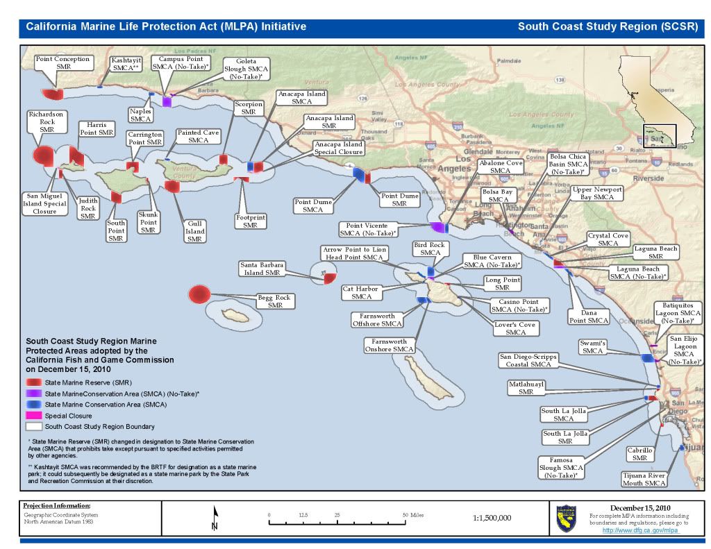 or you can go to this link so that you can zoom in... http://www.dfg.ca.gov/mlpa/pdfs/scmpas121510.pdf ...and not to be a dick but, comments stating that you'll be lobstering the edge of the reserve because that's where the action will be in a few years translates directly to, "MLPA's work" to the enviro's and can be used as fuel to feed this ridiculous fire. We've met a few times in the past (it's Larry right?) and really nothing personal, just my 2 cents...so take it for what its worth! |
|
|
|
|
|
|


 Hybrid Mode
