|
|||||||
| Home | Forum | Online Store | Information | LJ Webcam | Gallery | Register | FAQ | Community | Calendar | Today's Posts | Search |
 |
|
|
Thread Tools | Display Modes |
 04-29-2007, 08:20 AM
|
#1 |
|
Member
Join Date: Mar 2005
Posts: 61
|
Post-Islander SCI 4/27- Lost & Found
So, please, if you came home with a 2-piece, black handled, red bladed paddle (they are an off brand, purchased recently at Carlsbad Paddle Sports... not a Werner or Onno) could you get back to me here or email me at: pchartwell@gmail.com I called Fisherman's Landing when I got home and noticed they were not with me. The Islander had already left but someone had a look around and they didn't turn up. They suggested I contact OEX and I plan to do that as well. Thanks! |

|

|
|
04-29-2007, 09:07 AM
|
#2 | ||||||||||||||||||||||||||||||||||||||||||||||||||||||||||||||||||||||||||||||||
|
Member
Join Date: Mar 2005
Posts: 61
|
GOOD NEWS! Mine was picked up and they have a few other odds and ends so if you left something behind get in touch with the OEX Pt. Loma store; Adi should be bringing the wayward items there first of the week.
|
||||||||||||||||||||||||||||||||||||||||||||||||||||||||||||||||||||||||||||||||
|
|
|
||||||||||||||||||||||||||||||||||||||||||||||||||||||||||||||||||||||||||||||||
|
04-29-2007, 09:08 AM
|
#3 |
|
Junior Member

Join Date: Apr 2006
Posts: 21
|
Yep, Adi (sp?) has them... we tried finding the owners of several other items as well. If you are missing anything just ask. (Adi can drop them off at OEX too.)
Todd |
|
|
|
|
04-29-2007, 11:52 AM
|
#4 |
|
Senior Member

Join Date: May 2006
Posts: 698
|
There are no fish pics because we all agreed to keep it quiet.... and because dink bass photos belong somewhere else. lol That was really a great trip, the boat, the crew, the food, the beer, the tequila, the kayak fishing tribe, everything except the catching fish part. I'm going to try and get out again this season.
|
|
|
|
|
04-29-2007, 12:13 PM
|
#5 |
|
Junior Member

Join Date: Jan 2006
Location: Oceanside
Posts: 9
 |
I left a seeker rod with a daiwa baitcaster on the boat, unless it fell out of the truck...
|
|
|
|
|
04-29-2007, 02:56 PM
|
#6 |
|
Support your local pangas
Join Date: Feb 2007
Location: Lj
Posts: 976
|
Sammy my man your rod and reel are at OEX I believe, nice meeting you all and sorry I got sick all weekend.
Matt |
|
|
|
|
04-29-2007, 04:30 PM
|
#7 |
|
Senior Member

Join Date: Mar 2005
Posts: 2,568
|
Yep,
Paul and Sam - we got you covered. Not in OEX yet, I'll drop it off there tomorrow. I got Paul's paddle and a life vest, Sam's Seeker rig (the one Block almost caught that seal on... lol )... There's is another Hobbie paddle, lil' tackle box full of sinkers and another set of 3 rods that someone forgot - Saltist, Okuma and Shimano Calcuta bass rig!  It must have been all the exciting big game fishing we had to cope up with the whole day... lol It must have been all the exciting big game fishing we had to cope up with the whole day... lol The weather was epic, conditions better then anyone could wish for. YTs didn't show up, and you know how it goes with WSB and halibut... ") I have really enjoyed the trip. Islander is 1st class, skipper and the crew are just excellent! Bummer we didn't get big fish to cooperate. Great getting to know you guys better. 
__________________
 [------------------------ [------------------------ <)))< ....b-a-a-a-a |
|
|
|
|
04-29-2007, 04:34 PM
|
#8 |
|
Senior Member
Join Date: Mar 2005
Posts: 2,568
|
There's also a mini cooler, the red one...
 It will all be at OEX as of tomorrow 9:00 AM. Stop by and pick it up. One big bow down to Corey for letting the crew have all the JP money... Noble...  But next time give them 1/2 and move the other 1/2 to WCW winning pot, will 'ya? lol
__________________
[------------------------ <)))< ....b-a-a-a-a |
|
|
|
|
04-29-2007, 07:53 PM
|
#9 |
|
Junior Member
Join Date: Jan 2006
Location: Oceanside
Posts: 9
|
Thanks Adi! Ryan must have put it somewhere else in the rack after seal fishing?... out of sight out of mind I guess. Nice meeting all you guys, to bad the yellows didnt want to play.
|
|
|
|
|
04-30-2007, 12:58 PM
|
#10 |
|
Senior Member
Join Date: Mar 2005
Posts: 2,568
|
OK...
The unclaimed stuff is at OEX... We found an owner for 1 seeker rod & Daiwa reel, 1 paddle, and 1 life vest... The rest is still unclaimed, at least as far as I know. Here it is: 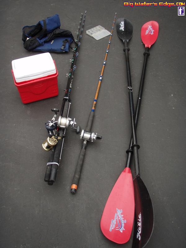
__________________
[------------------------ <)))< ....b-a-a-a-a |
|
|
|
|
04-30-2007, 01:05 PM
|
#11 |
|
Senior Member
Join Date: Mar 2005
Posts: 2,568
|
I keep forgetting:
- in addition, I found a small Pentax battery on Islander deck... Most likely for digital camera... I kept asking everyone while on the boat, but no one thought it is their’s. It’s got to belong to one of us. I got it, let me know if you realize later on you're missing it. 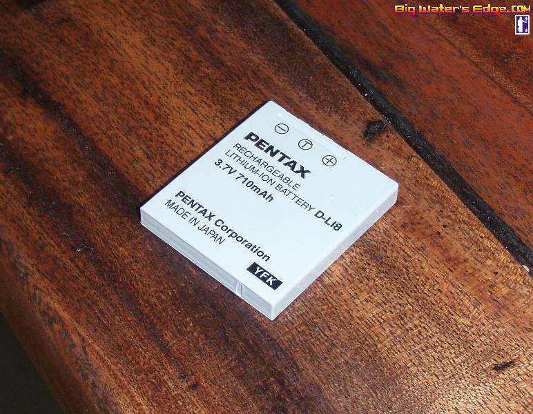
__________________
[------------------------ <)))< ....b-a-a-a-a |
|
|
|
|
04-30-2007, 01:26 PM
|
#12 |
|
Senior Member

Join Date: Mar 2005
Location: ...waaaay out there
Posts: 794
|
Dibs on the Saltist if no one claims it!!!

__________________
|
|
|
|
|
04-30-2007, 01:31 PM
|
#13 |
|
Senior Member
Join Date: May 2006
Posts: 698
|
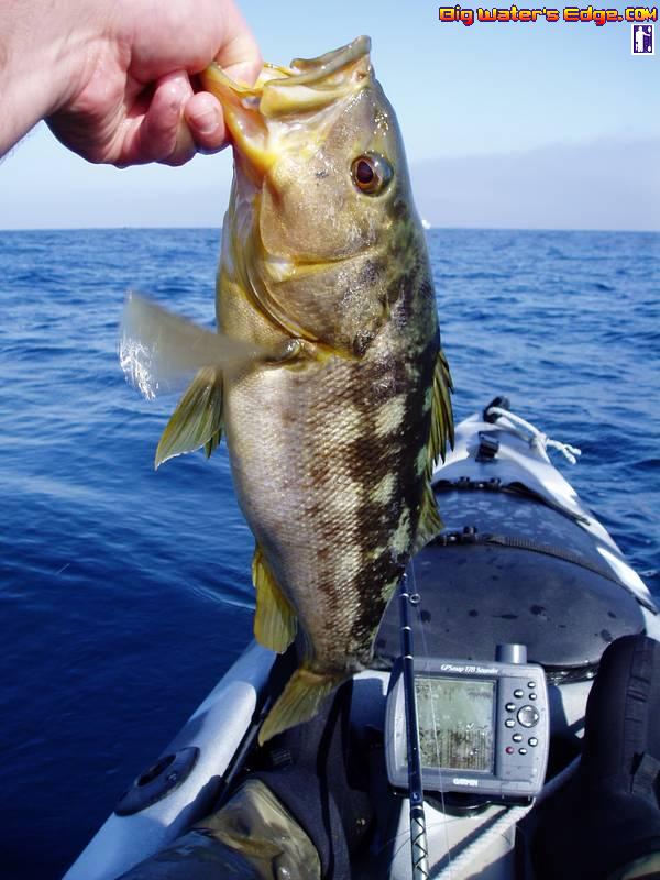
The Hobie paddle is mine, thanks for saving it. I didn't get many photos but here's a few.
Where the fish were not biting: 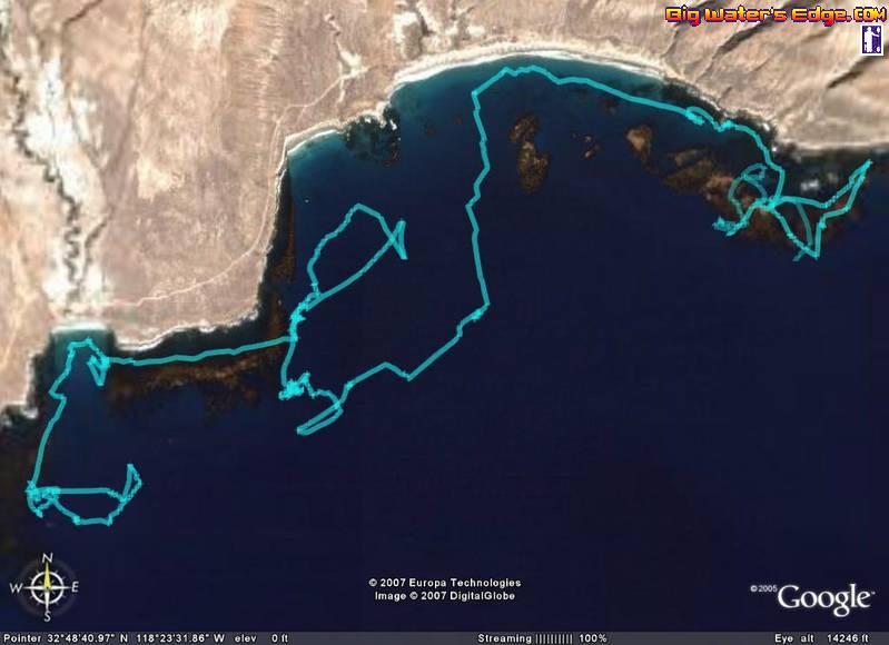 My best fish: 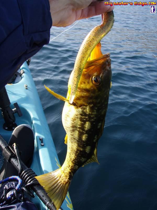 Saw plenty of marks on the fish finder, just not hungry fish. 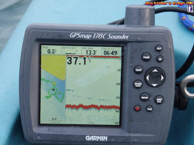
|
|
|
|
|
04-30-2007, 01:36 PM
|
#14 |
|
Senior Member
Join Date: Mar 2005
Location: ...waaaay out there
Posts: 794
|
That GPS track is cool, Dave. Nice cali on the slug. I forgot to try that. I'll post a few pics tonight when I get home.
__________________
|
|
|
|
|
04-30-2007, 01:57 PM
|
#15 |
|
Senior Member
Join Date: Mar 2005
Posts: 2,568
|
Dave, the shot of your tracks with Google Earth is awesome.
Are you using Google Earth Plus or your GPS supports regular Google Earth? I'm considering getting Google Earth Plus. I can supposedly plug my eTrex data into it. I got MapSource software and can get the similar "big picture" there, but Google Earth is way more cool.
__________________
[------------------------ <)))< ....b-a-a-a-a |
|
|
|
|
04-30-2007, 02:51 PM
|
#16 | |
|
Senior Member
Join Date: May 2006
Posts: 698
|
Quote:
|
|
|
|
|
|
04-30-2007, 04:50 PM
|
#17 |
|
Senior Member
Join Date: Mar 2005
Location: ...waaaay out there
Posts: 794
|
I didn't take many pics either but here's a couple. This one's the JP calico I caught twice.
 ..And this is the dinner prepared by Paul the galley chef of the Islander. It really is a classy operation all the way around. 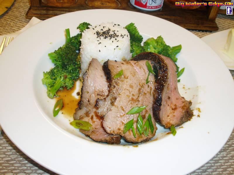
__________________
|
|
|
|
|
04-30-2007, 07:42 PM
|
#18 | |
|
Senior Member
Join Date: Mar 2005
Posts: 2,568
|
Quote:
I had MapSOurce 6.0 installed - integration with Google Earth wasn't there. I just updated it to the latest version - http://www8.garmin.com/support/downl...ils.jsp?id=209 Now I see the option... ...but it ain't working... Computers... 
__________________
[------------------------ <)))< ....b-a-a-a-a |
|
|
|
|
|
04-30-2007, 08:13 PM
|
#19 |
|
Senior Member
Join Date: Mar 2005
Posts: 2,568
|
got it!
Thanks Dave, this stuff is pretty cool! Here's my SCI no fish map :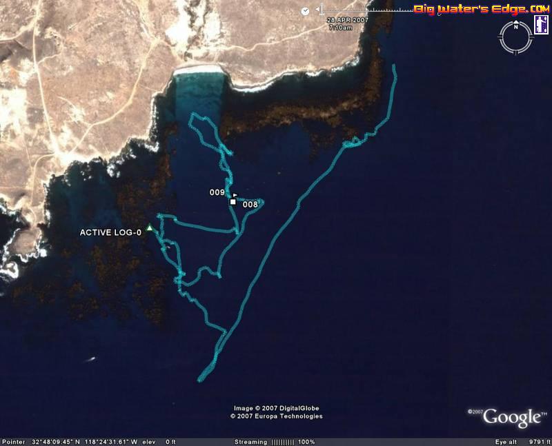
__________________
[------------------------ <)))< ....b-a-a-a-a |
|
|
|
|
04-30-2007, 08:39 PM
|
#20 |
|
Member
Join Date: Mar 2005
Location: Huntington Beach
Posts: 48
|
Man that tequila must've been strong stuff, made everyone forget their stuff on board.lol
 
__________________
Ron Pascual aka fishinHB |
|
|
|
|
|
|


 Linear Mode

