|
|||||||
| Home | Forum | Online Store | Information | LJ Webcam | Gallery | Register | FAQ | Community | Calendar | Today's Posts | Search |
 |
|
|
Thread Tools | Display Modes |
 02-02-2009, 08:27 PM
|
#1 |
|
Junior

Join Date: Jan 2009
Location: North Park
Posts: 20
|
Where is la jolla canyon?
|

|

|
|
02-02-2009, 08:34 PM
|
#2 |
|
Senior Member

Join Date: Mar 2006
Location: La Jolla Shores
Posts: 1,626
|
A depth sounder gps combo would help you find your way also a small investment in gps coordinates would help greatly.
|
|
|
|
|
02-02-2009, 08:49 PM
|
#3 |
|
Senior Member

Join Date: Nov 2008
Location: La Mesa
Posts: 386
|
If you paddle ABOUT a mile strait out to sea from the pier you will be over the canyon. It will take a fish finder to find exactly where the edge of it starts.
You'll know you're there when your iron takes an hour to reach bottom. |
|
|
|
|
02-02-2009, 09:14 PM
|
#4 |
|
The Good Clone

Join Date: Oct 2005
Location: Clairemont
Posts: 520
|
The Scripps canyon is the one that goes from about the northwest corner of the reserve (not to be confused with THE northwest corner) to that weird round building on the beach north of the pier.
Go to this link, click "My Topo" and wait for it to load the depth info. Topographical Map Note that it gives you the GPS coordinates just below the map as you move the mouse around. |
|
|
|
|
02-02-2009, 09:17 PM
|
#5 |
|
Senior Member

Join Date: Sep 2006
Location: Bay Ho
Posts: 1,382
|
This is a decent map of both canyons.

|
|
|
|
|
02-02-2009, 09:32 PM
|
#6 |
|
Senior Member

Join Date: May 2006
Posts: 698
|
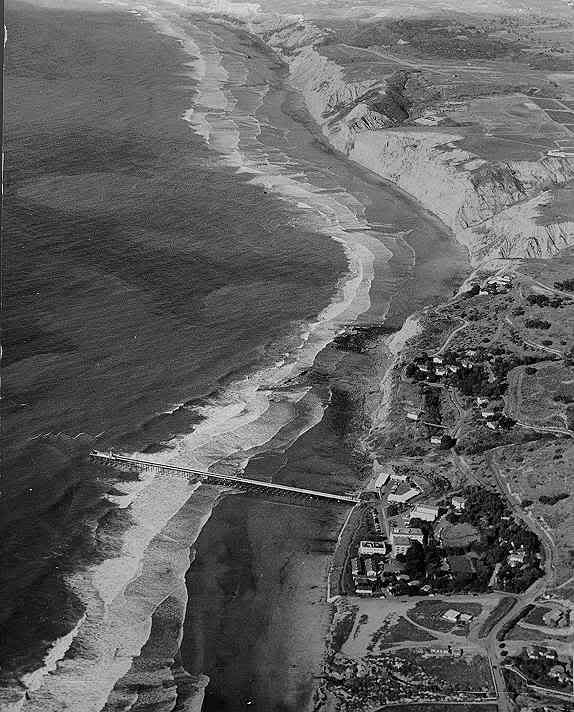
This 1952 photo shows Scripps canyon north of the pier, the other canyon (La Jolla) starts just south of the kayak launch, if you paddle due west from the launch you will cross it. They both connect out past the reserve line.
|
|
|
|
|
02-02-2009, 09:46 PM
|
#7 |
|
Senior Member

Join Date: Jul 2007
Location: San Pedro
Posts: 999
|
wow would been nice to snatch up a few acres back in 1952

|
|
|
|
|
02-02-2009, 10:03 PM
|
#8 |
|
Member

Join Date: Jan 2007
Location: Scripps Ranch
Posts: 82
|
The link below has fly-by videos of the La Jolla Canyon. These are large mpg files.
http://videos.windizzi.com/info?src=...60&duration=27 |
|
|
|
|
02-03-2009, 06:07 AM
|
#9 |
|
Senior Member

Join Date: Nov 2007
Location: San Diego
Posts: 279
|
I like this one as it shows the boundaries as well as the canyons.
La Jolla Map.jpg http://www.lajollaguide.com/ljsa/ima...ed1080x589.jpg
__________________
Don't try to confuse me with facts! I hereby reject your reality and submit my own. |
|
|
|
|
02-03-2009, 08:34 AM
|
#10 |
|
Member

Join Date: Jul 2008
Location: Encinitas
Posts: 600
|
beware of the HUGE leopard shark though....
|
|
|
|
|
02-03-2009, 08:38 AM
|
#11 |
|
Junior
Join Date: Jan 2009
Location: North Park
Posts: 20
|
Wow thanks guys. I got a pretty good idea of where Im gonna start trollin. Great maps and graphs.
|
|
|
|
|
02-03-2009, 09:15 AM
|
#12 |
|
Senior Member

Join Date: Mar 2007
Location: San Diego
Posts: 169
|
Let me know if you want to borrow my radio.
|
|
|
|
|
02-03-2009, 10:35 PM
|
#13 |
|
Member

Join Date: Jan 2009
Location: near palm springs
Posts: 82
|
HEY COULD SOMEONE TELL ME IF ITS WORTH GOING ALL THE WAY TO THE PIER to get bait AND HOW MUCH TIME DOES IT TAKE TO GET THEIR FROM THE LAUNCH AND HOW LONG TO GET TO THE KELP?
__________________
  
|
|
|
|
|
02-04-2009, 06:03 AM
|
#14 |
|
Senior Member
Join Date: May 2006
Location: C-bad
Posts: 431
|
It's not worth it in my opinion. Go straight out with the mindset of using artificials with a bait stick ready and it'll happen. You waste the best part of graylight. Now, if you launch at 4am it's a different story.
|
|
|
|
|
|
|


 Linear Mode

